

Route Corridor Options Public Consultation No. 1
TUESDAY 2ND JUNE - FRIDAY 5TH JUNE 2020
This was the first of the public consultations and the objective was to invite the members of the public to comment on the proposals. These comments will assist Kilkenny County Council in the development of the route options for the N25 Waterford to Glenmore Scheme. The Option Selection Phase is expected to be completed in Q1 2021 and has been progressed in accordance with TII’s ‘Project Management Guidelines’.
Option Selection
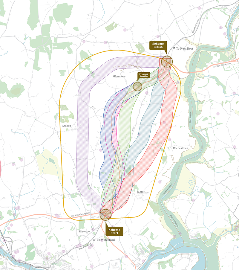
Stage 1 of the Option Selection Process has considered the identified constraints to develop a range of feasible options for assessment within the study area. These options have been assessed under three headings Engineering, Environment and Economy and six options have been shortlisted to proceed further in the Option Selection Process. These six route Corridor Options are illustrated on the map and available to view and provide feedback through the interactive map. Alternatively, detailed maps of each route corridor option are available to download here.
The route corridor options are typically 600m wide and these corridors represent the lands within which a road scheme could be developed and not the actual width of the road or the lands to be acquired. It should be noted that the boundary of a route corridor may be changed as the project develops to address any new constraints that might emerge during the consultation and design process.
During this public consultation we are inviting feedback on the Route Corridor Options. Please consider carefully the route corridors presented and submit your comments by clicking on the Leave Feedback button.
Feedback and submissions received through this public consultation process will be considered by the project team as part of the Option Selection Phase process. This will involve a detailed assessment of all six Route Corridor Options using our key assessment criteria.
The Option Selection Phase will identify an Emerging Preferred Route Corridor which will then be displayed at a future Public Display Event. This is expected to take place in Q3 of 2020. Updates, news and details of future public consultations will be published on this website and advertised in the local press and on social media.
Key assessment criteria for the Route Corridor Options


Download our Preferred Option map
A detailed map of the Preferred Option is available to download.
Download MapDownload Preferred Option brochure
The brochure outlining the Preferred Option is available to download.
Download BrochureWe are working in partnership with:
Preferred Option Public Display No.1 of 2021
WEDNESDAY 26TH MAY TO FRIDAY 4TH JUNE
The Preferred Option has been identified as the NAVY corridor and information is available through the interactive mapping and the detailed background information available to download from the ‘Public Display Event’ page.
Go back to home
Option Selection
The Project Team has completed an appraisal of the six route corridor options, published during the non-statutory public consultation held in June 2020. The Navy option has been identified as the Preferred Option. This has been assessed as providing the most sustainable solution and optimum balance of benefits and impacts in relation to the six criteria used when considering transport infrastructure projects. These key assessment criteria as per the icons opposite.
The purpose of the Public Display was to inform the public of the Preferred Option and to afford the public an opportunity to engage in the process should they have queries, concerns and comments relating to the Preferred Option. The Public Display Event is now closed but the detailed background information and reports will continue to be available to download from the Public Consultation page under the Public Display Event tab.
Key assessment criteria for the Route Corridor Options
Option selection report PDF's here
Main Report
Appendix A - Map of Trans European Network (TEN-T)
Appendix B - Cost Benefit Analysis Report & Traffic Modelling Report
Appendix C - Junction Strategy Assessment
Appendix D - Environmental Constraints Report
Appendix D - Constraints Appendices
Appendix E - Feasible Options for the Phase 2 Stage 1 Assessment
Appendix F - Phase 2 – Stage 1 Assessment Matrix
Appendix G - Phase 2 Stage 2 Route Options
Appendix H - Public Consultation Report
Appendix I - Phase 2 – Environmental Route Options Report - Stage 2 – (Project Assessment Matrix)
Environmental Route Options Appendices 1.1 to 2.9
Environmental Route Options Appendix 2.10
Environmental Route Options Appendix 2.12 to 3.1
Appendix J - Road Safety Audit - Stage F1
Appendix K - Road Safety Impact Assessment
Appendix L - Phase 2 – Option Selection Report - Stage 2 – Overall Project Assessment Matrix
Appendix O - Stage F (Part 2) Road Safety Audit
Download our Preferred Option map
A detailed map of the Preferred Option is available to download.
Download MapDownload Preferred Option brochure
The brochure outlining the Preferred Option is available to download.
Download BrochureWe are working in partnership with: